


| التعليمـــات |
| التقويم |
|
#242
 2011-06-04, 11:52 AM
|
||||
|
||||
|
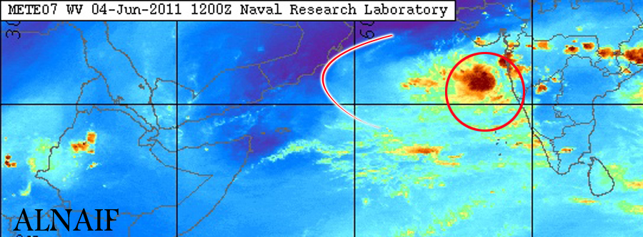
احتمال وبنسبة 60% بأن يولد المنخفض الفعلي يوم الغد الاحد ومع يوم الاثنين او الثلاثاء سوف يشكل عاصفه استوائيه وواضح الان من خلال صور الاقمار الصناعيه لحركة السحب اصبحت تأخذ وضع الدوران بشكل خفيف والله اعلم  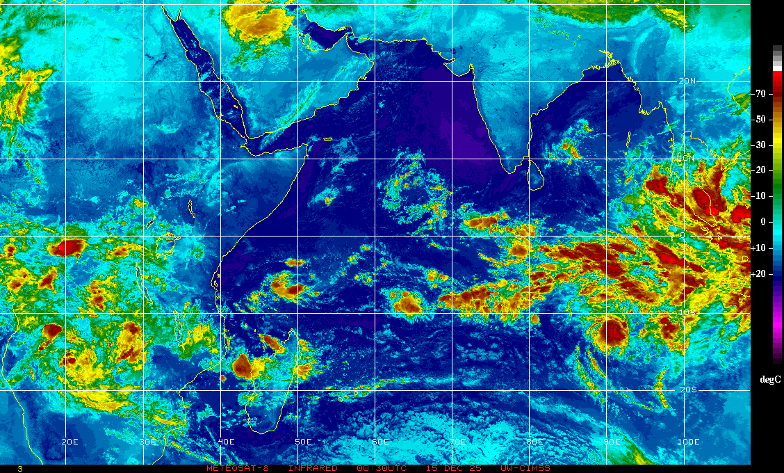
|
|
#243
2011-06-04, 12:14 PM
|
||||
|
||||
|
|
|
#244
2011-06-04, 12:18 PM
|
||||
|
||||
|
|
|
#245
2011-06-04, 12:31 PM
|
||||
|
||||
|
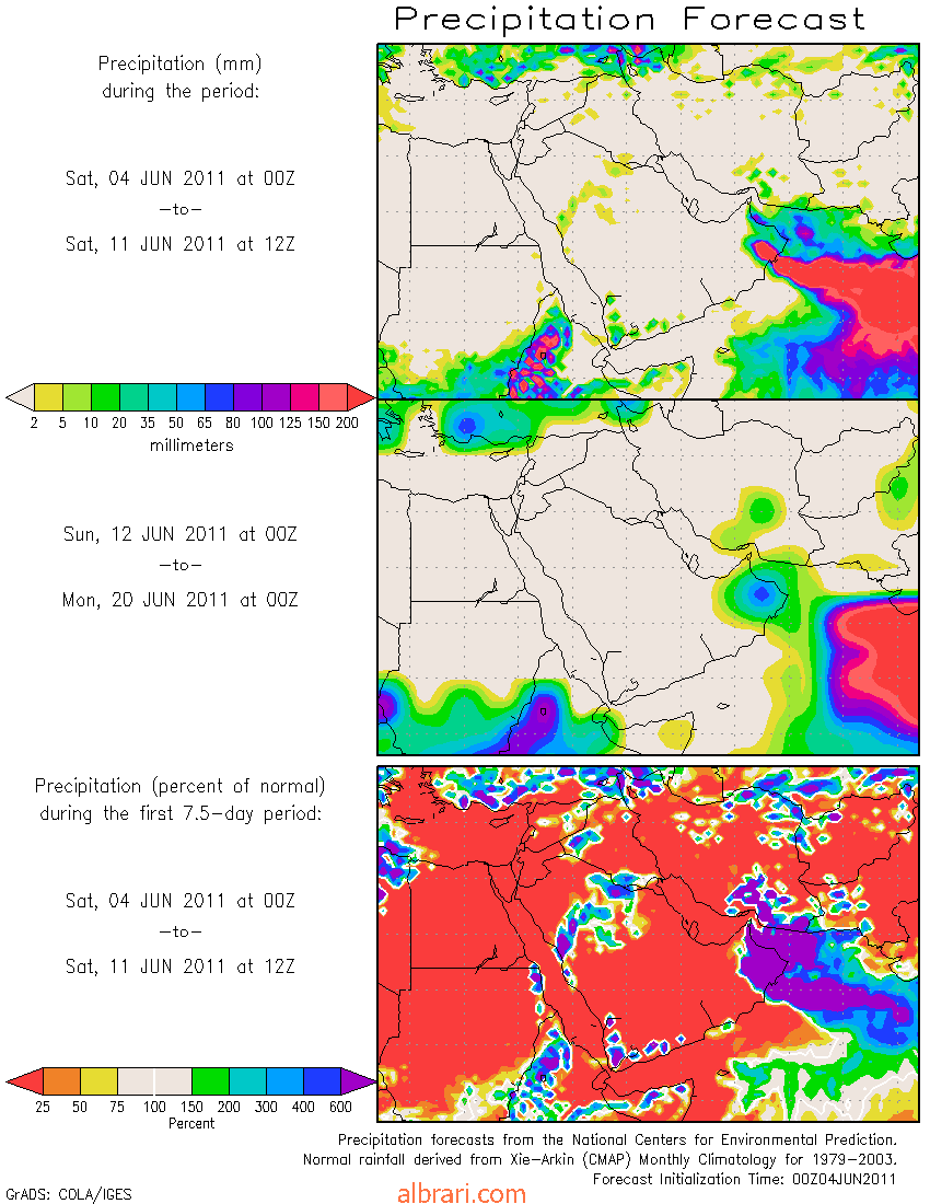
METD WEATHER AKSHAY DEORAS SEVERE WEATHER FORECASTER in an unexpected turn in the Tropical Weather system, the previous forecasted low pressure has vanished and the tropical wave has produced another band of thunderstorms in a region of SST over 28C which lacks presence of a lower convergence. This system has strong vortex system at the base,mid level. Various models confirm that the the forecasted low shall be a Warm Core Low as the warm moist air influxes in the system at lower levels due to torrential heating during spring season. Low-Mid level vorticity ( Vertical Vorticity) is favorable for upward lifting of parcel of air carrying moisture which is lifted adiabatically and the energy of the parcel is released at the upper level favoring where the system is having a weak upper air divergence ( Outflow of air aloft releasing heat of parcel) CIMSS models indicate a bare 5-10kt upper air divergence around the system located 730km SW of Mumbai. The area has a wind shear of around 20kt+ and the tendency of wind shear in 24hrs IS INCREASING. Convection is weakly organized around the geometric center as depicted by higher cloud top temperature of -30C. Typically strong lows ( Depressions) have Cloud Top Temp over -50C. The 850mb plots are showing developing LLC ( Low level cyclonic circulation) in the region which is a primary step for development of surface lows. The precipitation & surface pressure map shows a formation of 1000mb region by 5th June which shall intensify then. Precipitation map shows formation of weak rain bands in the region after 48hrs. Overall as per the 00z,4th June GFS shows unorganized shape of system. The GFS Cyclone Prediction maps show the system travelling WNW and expected to make a landfall in coastal Oman on by or on 11th June 2011. The system shall get chance of intensifying in Northern Arabian Sea as the Mid level wind shears have relaxed nature and the upper level winds are forecasted to be weak. The TPW-Precipitable Water shows 60mm+ precipitable water ( Good Moisture content) in the region! 
|
|
#246
2011-06-04, 12:43 PM
|
||||
|
||||
|
|
|
#247
2011-06-04, 01:54 PM
|
|||
|
|||
|
هذه آخر تحديثان ناسا ونلاحظ وصول العاصفة أو الإعصار الى عمان من جهت مصيرة خلال أسبوع
|
|
#250
2011-06-04, 03:28 PM
|
||||
|
||||
|
السلام عليكم وبارك الله في الجميع ومتابعه شيقه نسئل الله لكم الأجر والمثوبه وهذه نظره سريعه على المياه وحرارتها الحاليه وهي خارطه ليوم الأمس ويلاحظ بداية التكدس للمياه الدافئه بهذه المنطقه مما يوحي الأنطلاقه الفعليه بهذا الجزء المشار اليه بحول الله وهذه صوره للاحترار 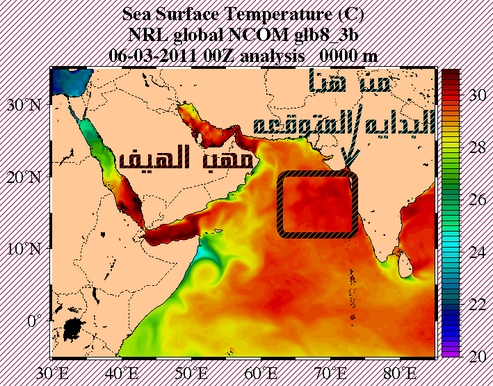 ونشاهد هنا بداية وضوح المنخفض بطبقات الجو العليا وكذلك الأختراق لطبقات المتوسطه والشبه السطحيه وهذا دليل لقوة المنخفض وتطوره من يوم الأثنين مابعد الغد الموافق 6-6 وهذه صوره توضح تواجده بجميع الطبقات المهمه 500 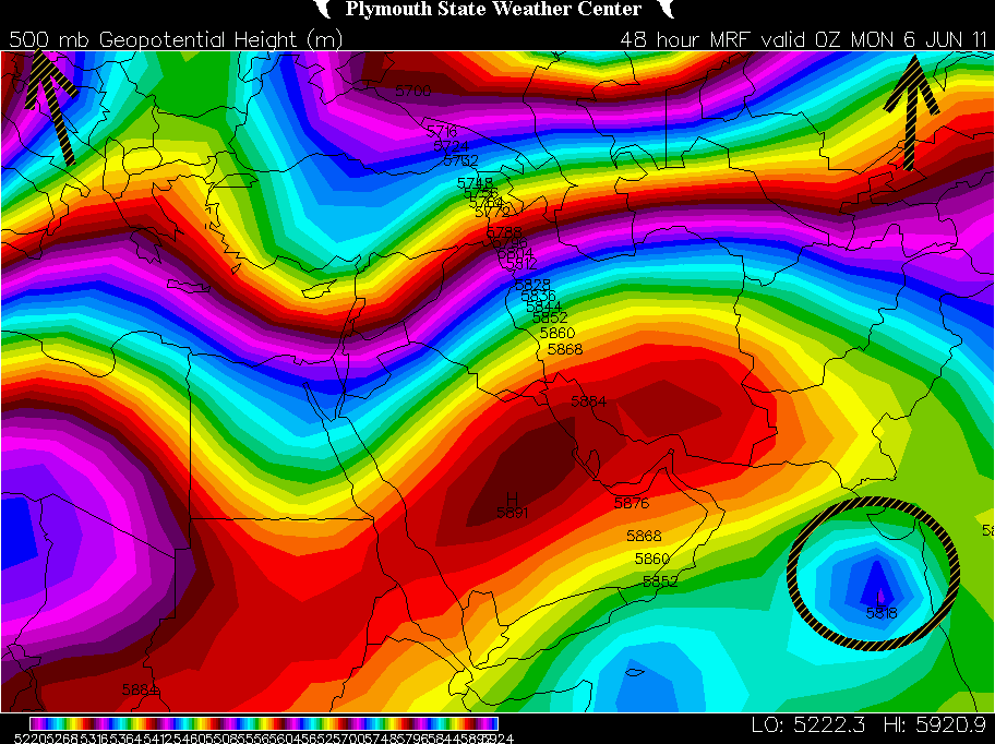 700 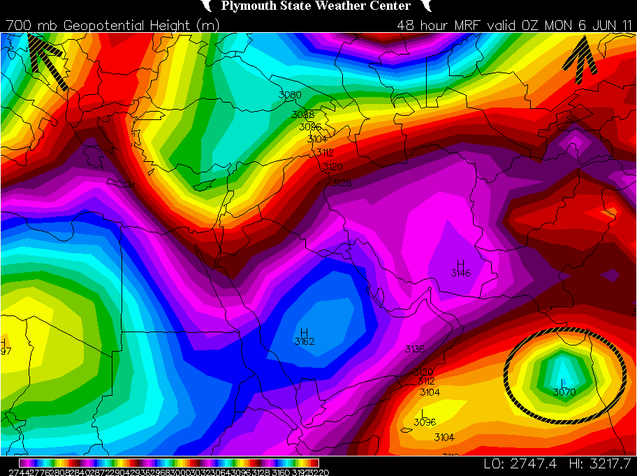 850 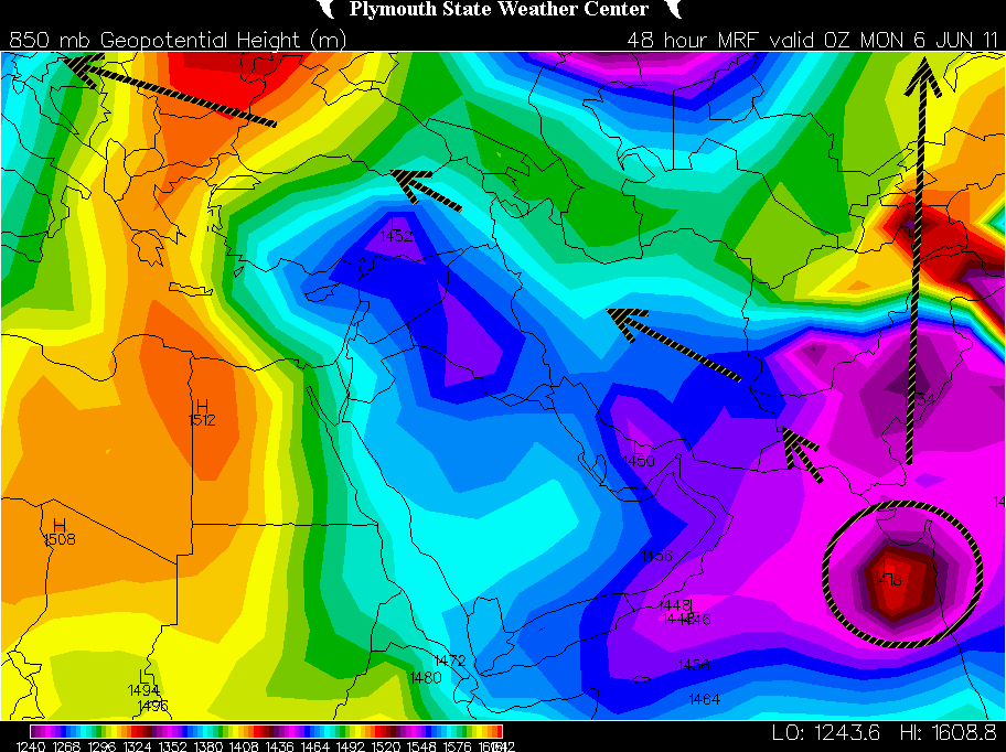 ونعرج على السطح والضغط به ونشاهد بداية التشكل الفعلي من يوم الأثنين ان شاء الله وأزدياده ووصول الضغط بداخله الى 994من يوم الثلاثاء والأستمرار المتوقع ليصل الى 985من يوم 10من الشهر نفسه ليؤثر على دولة عمان الشقيقه وكذلك دولة الأمارات وأجزاء من أراضي بلادنا الحبيبه من الركن الجنوب الشرقي والله اعلم تبقى توقعات ولانجزم بها والمعطيات تتغير بسرعه صوره لضغط السطحي من يوم 5وحتى يوم 13  الذي يهمنا الآن هو متابعة الأحترار وسيره وكذلك الضغوط السطحيه ووضعية الرياح وتقلبها فهذه العناصر كفيله ومهمه لوضع سير الحاله بحول الله ودقة التوقع لتحديد المسار ان شاء الله نسئل الله ان يحمي الجميع وان تكون امطار خير وبركه
|
 |
|
|


 العرض العادي

